Mail, Maps, and Where I Live:
Adventures with Toot and Puddle
(A Geography Unit for PreK - 2nd Grade Students)
Day 1
Before Reading:
Several days before starting the unit, send a letter to your student(s). With the letter, enclose a treasure hunt map that you have created using simple, noticeable landmarks or distinctives of your classroom, your home, or your backyard. Once the letter arrives and they open it, have them use relative location words such as next to, near, across from, etc. and follow the map to lead them to a book (Toot and Puddle by Holly Hobbie), a world map, black and white world maps, blue and green crayons, small circle stickers, and small star or heart stickers that you have hidden inside of a suitcase. (If using this at home, maybe include warm hats, sunglasses, and a snack for traveling as well!)
After the excitement of finding the suitcase and taking a peek inside, focus children's attention on the map. Let the children look at the map and describe what they see. What do they already know about maps? Point out that there are two main areas of a map. The land areas and the areas of water. Give each child their own black and white world map. Have them color the land areas green and the water blue.
Explain that the land areas are called continents and the large water areas are called oceans.
Locate where you live on the world map and place the star or heart sticker there. Explain that in the story of Toot and Puddle, one of the pigs wants to travel to lots of different places around the world while the other pig prefers to stay home. Have students brainstorm ways Toot could travel to get from where we live to both close and far away places. Where do you think he might go? Where would you want to go? What will he need to take with him? What type of clothes might he need? What might he need to take with him so he knows where he is going next? (clothes, suitcase, camera, maps) Explain that we will first read about all of Toot's adventures and then, after the story, we will use the circle stickers to map where he went.
After Reading:
Place a circle sticker on each place Toot visited. Write a numeral 1 on the first destination, a numeral 2 on the second destination, etc.

Toot's destinations:
Kenya, Africa
Nile River, Egypt
Solomon Islands, Australia
Bombay, India
Mont Blanc in the Alps
Spain
South Georgia, Antarctica
Paris, France
Florence, Italy
Day 2
Review with students what happened in the book, Toot and Puddle. Which location was their favorite from the story? Why?
Look closely at the postcards that Toot sent to Puddle. Point out the common elements such as the stamp, postmark with date and location, the cancellation mark, the opening, the closing, the address, etc. Bring in real pieces of canceled mail as well to locate the similar items on letters and envelopes (such as the ones children received in the mail from you).
Watch a video or read a book such as Here Comes the Mail by Gloria Skurzynski,
The Post Office Book: Mail and How It Moves by Gail Gibbons, A Day with a Mail Carrier by Jan Kottke, and/or Where Does the Mail Go? by Melvin Berger to learn how mail is delivered and where it goes once you send it!Write postcards and send them to friends or relatives!
Day 3
Read Where Is My Continent? by Robin Nelson. Stress that we (and Toot and Puddle) live on the continent of North America, which is between the Atlantic and Pacific Oceans. Look at the world map where we marked Toot's travels. Did Toot visit any places in North America?
Teach children the names of the six other continents as well. Sing 'The Continents Song', using either the one created by Dr. Jean or the one based on Dr. Jean's song which has a slight change of words (for Christian schools/families).
Continents Song - on Dr. Jean's Sing To Learn CD
(corresponding booklet created by Martha Shehan)
Continents Song - altered with permission
Help students to name and locate all seven continents using clues, such as the following…
North America – the continent where we live
South America – the continent just south of North America, our neighboring continent
Europe – the continent attached to Asia with only mountains dividing them
Asia – the largest continent
Africa – the continent in which part of it is covered with the largest desert in the world
Australia – the smallest continent, which is also an island. (In the book of Toot and Puddle, Toot visits the Solomon Islands, which are part of the continent of Australia. Locate the Solomon Islands that Toot traveled to. Define an island as being land that is completely surrounded by water.)
Antarctica – the continent on the bottom of the globe. It is very cold here and is covered in ice. It is so cold that scientists only stay there for a short time. Only penguins live along the shore. The summer is only as warm as our winter.Which continents did Toot visit? Which continent did he visit most often? Which continents did Toot not visit?
Day 4
Sing 'The Continents Song' and review the names and locations of each continent.
Help students to name and locate the five oceans.
(You may also want to take time to explain that oceans are salt water and cover almost ¾ of the earth's surface. Show ¾ of a circle to demonstrate that there is more water than land on the earth. We cannot drink water from the ocean! We can only drink water that comes from fresh water sources such as rivers and lakes, which do not contain salt.)
Pacific- the largest ocean, west of United States, between North America and Asia.
Atlantic- the second largest ocean, east of the United States, between North America and Europe, curves like an 's'
Indian- South of Asia, the country of India seems to point towards it, north of Antarctica, south of Asia, east of Africa
Arctic- north of North America, surrounds the North pole (The Arctic is not near Antarctica! The Southern ocean is there.)
Southern - Not all maps have this one labeled. It is directly north of Antarctica and is the southern most ocean.Work on a world puzzle together.
Reread Toot and Puddle or listen to a recording as students follow along in the book.
Ahead of time, pack a large purse or satchel with 'souvenirs' that Toot might have brought back from each location of his journey. Let students take turns pulling out an item, describing it, and then trying to determine which location it might have come from. (They can look at the pictures of Toot's travels in the book for help.) Point out the location on the map, reiterating the name of the continent he was visiting.
Day 5
Sing 'The Continents Song' and review the names and locations of each continent.
Review the names and locations of the five oceans.
Find the equator on a globe. It is an imaginary line to divide the top and bottom half of the earth. Near the equator, it is very warm all year long no matter what season. As we travel north or south of the equator, it becomes colder. Locate the Northern Hemisphere and the North Pole as well as the Southern Hemisphere and the South Pole. Explain that the seasons are opposite in the Northern and Southern Hemispheres. For example, if it is summer in the Northern Hemisphere, it would be winter in the Southern Hemisphere.
Locate where we live on the world map. Are we located in the Northern or Southern hemisphere?
Review all the locations that Toot visited. Did he travel to any places that were in the Southern Hemisphere/Northern Hemisphere? Which ones? (Most areas that Toot visited were close to the equator or in the Northern Hemisphere.)
Look back at the pictures in the book. Were Toot and Puddle experiencing different seasons?
What clothing did Toot need at each location? (Make a suitcase using a folded piece of 9 by 12 construction paper and some handles. Label one side of the suitcase 'warm climate' and the other 'cold climate'. Color, cut out, and sort the clothing according to which climate they would be needed in.)
Printables:
Seasonal Clothing
Seasonal Clothing BW
Climate Labels
Climate Labels BW
Day 6
Review the names and locations of the continents, oceans, equator, and the Northern and Southern Hemispheres.
At the beginning of the story, Toot was looking at a globe. Do you think Toot packed the globe with him? Why not? What do you think he packed instead? What types of maps would he have needed?
How would he read the maps? Collect and share a variety of maps, such as maps for a local park, grocery store, airport, museum, zoo, city, state, country, and world. Read a book such as Mapping Penny's World by Loreen Leedy. Note the key, symbols, and compass rose on each map in the story and on the real ones.
Reinforce the cardinal directions (North, South, East, West).
Revisit the world map in which you marked Toot's travels. Follow his path and note whether he travels North, South, East, or West to reach his next destination.
Day 7
Read Me On the Map by Joan Sweeney.
Then, have students either make a map of the classroom or a room in your home, if you are homeschooling. Brainstorm and make a list items in the room that can be placed on the map. Have children draw the items in the room by location. Then, have students describe items in the room using relative locations such as next to, near, across from, etc. Mark the cardinal directions for the room using North, South, East, and West. Then ask questions, such as 'If you stood at the door to the room, which direction is the window?'
Day 8
Toss an inflatable globe. Does your thumb land on land or water? What is the name of the continent or ocean that your thumb landed on? Is your thumb in the Northern or Southern Hemisphere? What is directly North of where your thumb is? South? East? West?
Look back at the postcard that Toot sent to Puddle. How did the mailman know who and where to deliver the postcard? What is Puddle's address? What is your address? Read Where Do I Live? by Neil Chesanow. Practice saying your address.
Play a mail delivery game in which students take turns reading envelopes with 'addresses' on them and delivering them to the correct 'house'.
Day 9
Review what we have learned so far about our world.
Sing 'The Continents Song'.
Put together the world puzzle as you further review the oceans and continents.
We live on Earth, on the continent of North America. Now, stress that North America has three large countries – Canada, the United States of America, and Mexico. Central America is a skinny area of land with lots of small countries, connecting the continents of North and South America. Use a key to color code the countries in North America, and the area called Central America.
Review stating your address.
Day 10
Next, stress that we live in the country called the United States of America, which is made up of fifty states!
Read a book about the United States of America.
Locate the capital of the United States and place a picture of the White House there.
Complete a puzzle of the United States of America.
Day 11
On a US map, locate the state you live in.
Read a book about the state you live in.
Use a key and a map of the US to color the state you live in. For example, color Indiana and the surrounding states (north-Michigan, south-Kentucky, east-Ohio, and west-Illinois).
Which is larger – a continent, a country, or a state?
Complete a puzzle of the United States of America.
Day 12
Inside of states are many cities. Read a book about cities.
Locate the capital of the state you live in. Also, locate the city where you live.
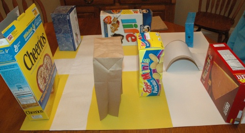
On large chart paper, draw and map out a few primary roads in your city. Take photos of some nearby places such as stores, a bank, gas station, fire station, school, our neighborhood, park, etc. Print the photos and place them on the map. OR Print a map of your city using maps.google.com . Print photos of places in your city. Place large dots next to the photos and smaller dots on the map where those places are located. Number the dots accordingly. Give students directions to one of the places and let them discover where they traveled to.
Day 13
Located in our city are various neighborhoods. Read a book about neighborhoods.
Review stating your address.
View our street and home (or your school) using maps.google.com .
Make a map of our street and the surrounding houses.

Day 14
Sing 'The Continents Song' and review the names and locations of each continent, the names and locations of the five oceans, the equator, and the Northern and Southern hemispheres.
Read My Global Address by Tamara Nunn.
Complete your own 'Where I Live' booklet.
Printables:
Where I Live (US)
Where I Live (Indiana Version)
Day 15
Read Maps and Globes by Harriet Barton. Then, ask some general questions about maps and globes…
How is a map different from a globe?
Why do we need maps? What do we use them for?
What can we see on a map?
How is a political map different from a physical map?Review the names and locations of the continents, oceans, equator, the Northern and Southern Hemispheres, Canada, United States, Mexico, your state, your city, and personal addresses.
Geography and Missions
Would you and your children like to travel the world - learning about maps, exploring countries and cultures, and praying for people of the nations? Start with a condensed version of ‘Mail, Maps, and Where I Live’ and then travel the globe! Geography and Missions contains a list of books, a possible schedule for your world adventure, as well as coordinating notebook pages to keep track of your learning! (Suggested for grades 2nd-5th)
Additional Ideas:
Practice reading and following maps in real situations
Use a map in the grocery store to locate certain aisles and items. Use a map at a park with hiking areas to locate trails, playground, picnic areas, restrooms, etc. Use a map at a museum to locate exhibits or at a zoo to find specific animals.
Puzzles!
Put together a world puzzle or a puzzle of the United States.

Learn about using a compass.
Make a paper compass rose. Label. Discuss the more specific directions of northeast, northwest, southeast, and southwest. Then, try using a real compass. Give specific directions to move around a large room, the backyard, a nearby playground, etc.Make a small make-believe town!
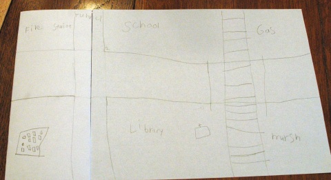
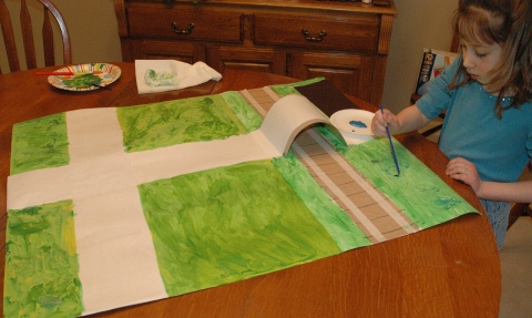
Collect boxes of all shapes and sizes, toilet paper rolls, small brown lunch sacks, construction paper, popsicle sticks, etc. Think about what you want your town to have available - a library, school, homes, a store, park, etc. Use paper to create a small map of your town. Then, set to work constructing buildings, trees, etc. from your collected materials!

Flat Travelers
Read Flat Stanley by Jeff Brown. Send a 'Flat Stanley' type of paper person in a letter to a far away family member. (Maybe create a pig and name him Flat Toot!) Ask them to take photos of the 'Flat Stanley' while doing their everyday activities and visiting areas of interest that are where they live. If you send your flat person to a variety of people and locations, over time, you may be able to collect postcards and information from many areas of the United States and, hopefully, the world. Each time you receive 'Flat Stanley' back, mark the location on a large world map. Send a thank you note to the person/family that sent you a postcard. OR Exchange 'Flat Stanley' with other homeschool families!Animals of Each Continent
Place an animal indigenous to each continent on the corresponding continent (examples below) and discuss how climate or habitat makes it possible for them to live where they are. Read a related book for each!
North America – buffalo
South America – llama (Andes mountains)
Europe – reindeer (northern part - Norway)
Asia – panda (China)
Africa – giraffe, lion, zebra
Australia – kangaroo, koala bear
Antarctica – penguin – NO polar bears. They live at the North Pole =)Missionaries to the Continents
Learn about 1 missionary that has served on each of the corresponding continents (examples below).
(Use YWAM's Heroes for Young Readers books and/or CDs to learn more about the missionaries.)
North America : Cameron Townsend (Mexico), Dwight Moody (USA)
South America : Jim Elliott, Nate Saint (Ecuador)
Europe : George Muller (England), Corrie ten Boom (Holland)
Asia : Lottie Moon (China), Jonathan Goforth (china), Gladys Aylward (China), Hudson Taylor (China), Adoniram Judson (Burma, now Myanmar), Amy Carmichael (India), William Carey (India), Eric Liddell (China)
Africa : David Livingstone, Mary Slessor (Nigeria)
Australia : Florence Young (New Zealand)
Related Read Aloud Stories and Resources:
Toot and Puddle by Holly Hobbie
Toot and Puddle: Top of the World by Holly Hobbie
Where Does Mail Go? by Melvin Berger
The Post Office Book by Gail Gibbons
Here Comes the Mail by Gloria Skurzynski
A Day with a Mail Carrier by Jan Kottke
Flat Stanley by Jeff Brown
Mapping Penny's World by Loreen Leedy
Me On the Map by Joan Sweeney
Where Do I Live? by Neil Chesanow
My Global Address by Tamara Nunn
Maps and Globes by Harriet Barton
How We Learned the Earth is Round by Patricia Lauber
Our World: A Child's First Picture Atlas by the National Geographic Society
Rookie Read About Geography by Judith Jensen Hyde (There is a book for each state in this series!)
The Seven Continents (Rookie Read About Geography) by Allan Fowler
The Four Oceans (Rookie Read About Geography) by Wil Mara
North America (Rookie Read About Geography) by Allan Fowler
South America (Rookie Read About Geography) by Allan Fowler
Europe (Rookie Read About Geography) by Allan Fowler
Asia (Rookie Read About Geography) by Allan Fowler
Africa (Rookie Read About Geography) by Allan Fowler
Australia (Rookie Read About Geography) by Allan Fowler
Antarctica (Rookie Read About Geography) by Allan Fowler
Where Is My Continent? by Robin Nelson
Where Is My Country by Robin Nelson
Where Is My State? by Robin Nelson
Where Is My Town? by Robin Nelson
Where Is My Home? by Robin Nelson
Be My Neighbor by Maya Ajmera and John Ivanko
Living in a City by Lisa Trumbauer
Living in a Rural Area by Lisa Trumbauer
Living in a Small Town by Lisa Trumbauer
Living in a Suburb by Lisa Trumbauer
Children Just Like Me by Barnabas and Anabel Kindersley
Heroes for Young Readers (series) - missionary stories from YWAM Publishing
Around the World in 80 Tales by Savior Pirotta
Around the World Art and Activities: Visting the 7 Continents Through Craft Fun by Judy Press
Around the Town: Exploring your Community Through Craft Fun by Judy Press
Social Studies Grade K- 1 - published by Frank Schaffer Publications